Lessons From the Mother Road About Government
The Big Picture Home Page | Previous Big Picture Column | Next Big Picture Column
Lessons From The Mother Road About Government
Published in the Maryland Daily Record November 5, 2012
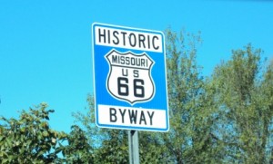
The Mother Road, John Steinbeck called it:[1] U.S. Route 66, which once linked Lakeshore Drive in Chicago with the Santa Monica Pier, spanning eight states and three time zones in the process. They decommissioned it in 1977, but, like a glorious zombie, it lives a postmortem life, preserved with maps, books, road signage, and of course the song about getting your kicks on Route 66 popularized by Nat King Cole, still covered to this day.
I recently had the privilege of driving the 2400+ miles[2] of what remains of it.
And yes, while driving it I certainly contemplated what a great and beautiful and just big country we inhabit. But I also thought about the power of government programs. They’re hard not to think about on 66.
Highway 66 itself is one of three arguably redundant programs you see, frequently in the same glance, as you travel from Tulsa through Oklahoma City, Amarillo, Albuquerque, Winslow, Flagstaff, Kingman, Needles and Barstow.
Transcontinentals
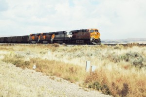
This bracelet of towns was largely strung together by one of the misleadingly-named “transcontinental” railroads,[3] the old Santa Fe, whose conveyor belt of freight trains still thunders eastwards[4]along the same course, about one every ten minutes.
The railroads may have been private companies, but they were quintessentially government programs. Historian Richard White has commented: “The transcontinentals, more obviously than other railroads, were entwined with the state. Governments subsidized them, secured their rights of way, regulated them, and protected them.”[5] This entwinement began with the Pacific Railway Acts of 1862[6] and 1864,[7] and continued with a constant stream of government bonds, tariffs, franchises, land patents and the like.
White believes that for the promoters, the government benefits were the actual name of the game, and that there was no fundamental economic rationale for the railroads at all, at least not when they were built, meaning that at the time they were a bad deal both for the taxpayer and the market. (The Panics of 1873 and 1893 were directly tied to railroad failures.)
But one good thing is for sure: the rails bound the towns together. This was by design; the Arthur Wellington treatise Location of Railways, the bible of 19th-Century railway engineers, laid it down as a rule that rights-of-way should be designed to link major centers of population.[8] And of course every few miles along the railroad, you had to have a depot. (The Union Pacific had one every eight miles.)[9] Many small towns were born as rail depots.
U.S. Highways
Along 66, the tracks and the roadway are seldom far from each other. And this was no surprise. They had to go the same places. In that era, public highways also linked town to town. This was less by design than necessity; the first federal appropriation intended to promote a national highway system was in 1916, for “rural post roads.”[10] But by the time the state highway commissioners got together in 1925 and 1926 for the great log-rolling session that gave us the familiar white-shield U.S. Routes,[11] those Routes were about the cities and the towns strung along them.
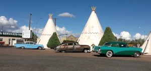
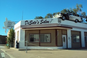
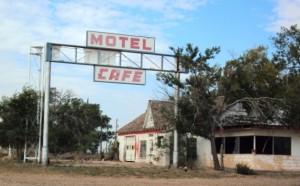
And all along 66, you can see the benign effects of this “stimulus program” on those cities and towns. For a generation or two, Route 66 was the way most Americans drove west, causing motels and diners and other businesses to spring up. Whether the travelers were Steinbeck’s Okies fleeing the Dust Bowl or the young men whose trip from upstate New York to college in Arizona is reconstructed at the Route 66 Museum in Chandler, OK, there seems to have been an optimism and good cheer about travel along this road. And it called forth an amazing crop of “follies,” idiosyncratic outpourings of architecture, sculpture, murals and neon, that glorified the cars, trucks, and motorcycles passing by. Motels made of plaster wigwams, restaurants topped with gargantuan sombreros or milk bottles, Burma Shave jingles in cornfields, jauntily-skewed Route 66 signs outlined in neon on archways decorated with Native American designs, it is sometimes close to insane, and all, all quintessentially American.
Yet now much of dynamism has now been reduced to nostalgia, some of it on beyond threadbare. Again and again on Route 66 you pass through ghost towns like Glen Rio, Texas, from which all humanity has fled, where graffiti-covered buildings without windows or roofs bear witness that once there had been communities. More typical are hardscrabble main streets like those in Galena, KS, Ash Fork, AZ or Ludlow, CA, where a few merchants hold extinction at bay, typically by playing 66 nostalgia for all it’s worth.
Interstates
What happened was that government programs gave, and they took away. The taking away took the form of the Federal-Aid Highway Act of 1956,[12] which established the Interstates. The Interstates did not turn out to be about downtowns, especially small-town downtowns, although they were sold to Congress that way.[13] The American Association of State Highway and Transportation Officials’ Policy on Design Standards – Interstate System (sort of a latter-day successor to Wellington’s book on railway design) ordains that in rural areas exits should be three miles apart. And when I-40 replaced much of U.S. 66, it went through the hearts of the Oklahoma Citys, but left the Glen Rios by themselves.
So now as you drive along the remains of 66, you can frequently see I-40, often up close, sometimes off in the distance under the big Western skies. Much of the time you can hear the rustle of the traffic. But you can only get to it about once every three miles. And so perfectly good small highway-oriented towns were left to wither, and in their place we got exitvilles: colonies of gas stations, convenience stores, and chain eateries that grew up around the Interstate cloverleafs. Exitvilles are generally functional, but in their sameness they repudiate the wild idiosyncrasies that made old Route 66 so colorful.
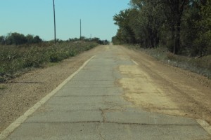
Once I-40 came through, maintaining both it and the Mother Road made little sense. Even so, the quantity of sheer waste is staggering when you see it. 66 was a huge achievement in its day. Much of it lies abandoned now: rough brownish Portland pavement, at best relegated to the role of service road to the new Interstates, at worst crumbling or totally crumbled in the middle of nowhere. Which is not to say that the Interstates haven’t brought us the speed and geographic connection they promised. When you build 41,000 miles of new road, some good things are bound to happen.
Lessons
In the course of the current election, you hear candidates talk as if government programs are pointless or powerless. Do not be taken in. An immense amount occurs as the results of government programs, both good and bad. Without the Pacific Railway Acts, two Panics might have been avoided, but that Santa Fe superhighway of container cars might never have come to pass. And it is hard to guess what America would have been without the large-scale national system created by the state highway commissioners in 1925 and 1926. Would World War II have been as winnable without highways for trucks carrying airplane and tank parts? And modern America without its Interstates is simply unimaginable; this point requires no discussion. When government acts, people’s lives change, both for the better and the worse. The three layers of government programs visible from Route 66 exemplify that.
[1] John Steinbeck, The Grapes of Wrath, Kindle Edition, page 118, Location 2937 (1937).
[2] Michael Wallis, Route 66: The Mother Road, at 1 (rev. ed. 2001).
[3] In quotes because none of them ever got east of Chicago, and in their 19th-Century heyday they seldom got even that far east. But it was what people called them.
[4] What goes east must come west, of course. That said, I don’t know where the westbound trains were, but over several days, the eastbound trains unmistakably predominated.
[5] Richard White, Railroaded: The Transcontinentals and the Making of Modern America, Kindle Edition, Location 385 (2012).
[6] 12 Stat. 489 (1863).
[7]13 Stat 356 (1965).
[8] As quoted in White, Kindle Edition, Page 148, quoting the 1891 edition of Wellington’s book, at 719-21. The theory, of course, was that major centers of population gave rise to traffic, and the railroad should go where the traffic was greatest.
[9] The theory being that four miles each way was as far as a farmer bringing produce in for shipment would be willing to go in a day’s round trip.
[10] 39 Stat. 355 (1916).
[11] Described at length in Richard F. Weingroff’s entertaining and erudite paper, From Names to Numbers: The Origins of the U.S. Numbered Highway System (1997), reprinted here.
[12] Public Law 84-627 (1956).
[13] Tom Lewis, Divided Highways at 120-21 (1997).
NOTE ON THE FINAL IMAGE: If it looks to you as if the road was only one lane wide, you’re right. At this spot near Afton, Oklahoma, the right-of-way is two lanes wide, but the paved portion only one, doubtless a concession to the limited financial resources available to pave this section. I’m guessing the idea was that the original travelers would at least have one-half paved lane for their tires to grip.
Copyright (c) Jack L. B. Gohn
The Big Picture Home Page | Previous Big Picture Column | Next Big Picture Column
